
Thank you for supporting this site ❤️
Make a donation
Make a donation
Gear up for your next adventure:
As an Amazon Associate, this site earns from qualifying purchases at no extra cost to you.
Cubos topographic map
Click on the map to display elevation.
Thank you for supporting this site ❤️
Make a donation
Make a donation
Gear up for your next adventure:
As an Amazon Associate, this site earns from qualifying purchases at no extra cost to you.
About this map
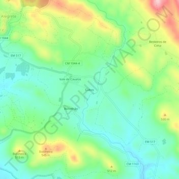
Name: Cubos topographic map, elevation, terrain.
Location: Cubos, Alegrete, Portalegre, 7300-335, Portugal (39.20358 -7.31905 39.24358 -7.27905)
Average elevation: 1,453 ft
Minimum elevation: 1,207 ft
Maximum elevation: 1,946 ft
Thank you for supporting this site ❤️
Make a donation
Make a donation
Gear up for your next adventure:
As an Amazon Associate, this site earns from qualifying purchases at no extra cost to you.