
新邵县 topographic map
Interactive map
Click on the map to display elevation.
新邵县
新邵地处雪峰山脉,雪峰山自西向东穿过全境,主要山峰有龙山 (山峰)、金龙山、板竹山。主要河流为资水及其支流龙山河、石马河、涣溪河、酿溪河、棠溪河、龙口溪河和岱水河。境内地势南高北低,东北、西北以山地为主,东南和西南以丘陵为主;最高点为龙山主峰岳平顶,海拔1513米。
About this map
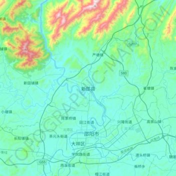
Name: 新邵县 topographic map, elevation, terrain.
Location: 新邵县, 邵阳市, 湖南省, 中国 (27.16456 111.29412 27.48456 111.61412)
Average elevation: 1,119 ft
Minimum elevation: 594 ft
Maximum elevation: 4,072 ft