
Make a donation
Gear up for your next adventure:
As an Amazon Associate, this site earns from qualifying purchases at no extra cost to you.
Hechtsheim topographic map
Click on the map to display elevation.
Make a donation
Gear up for your next adventure:
As an Amazon Associate, this site earns from qualifying purchases at no extra cost to you.
Hechtsheim
Mainz-Hechtsheim ist einer der südlichen Stadtteile von Mainz und befindet sich in einer von Süden nach Norden abfallenden Talsenke (zwischen 175 m ü. NHN und 130 m ü. NHN), der höchste Punkt ist die Laubenheimer Höhe mit 196 m ü. NHN. Die kath. Pfarrkirche St. Pankratius befindet sich auf einer Höhe von 168 m ü. NHN, die Ortsverwaltung auf 148 m ü. NHN. Mitten durch Hechtsheim, jedoch zwischen Militärstraße und Autobahntunnel voll kanalisiert, fließt der Schinnergraben, ab Gemarkungsgrenze Bretzenheim als Wildgraben.
Make a donation
Gear up for your next adventure:
As an Amazon Associate, this site earns from qualifying purchases at no extra cost to you.
About this map
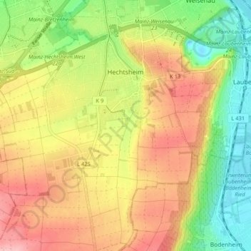
Name: Hechtsheim topographic map, elevation, terrain.
Location: Hechtsheim, Mainz, Rheinland-Pfalz, 55129, Deutschland (49.92827 8.23614 49.97969 8.29783)
Average elevation: 495 ft
Minimum elevation: 266 ft
Maximum elevation: 722 ft
Make a donation
Gear up for your next adventure:
As an Amazon Associate, this site earns from qualifying purchases at no extra cost to you.
Other topographic maps
Click on a map to view its topography, its elevation and its terrain.
Mainz
Deutschland > Rheinland-Pfalz > Mainz
Mainz befindet sich auf einer Höhe von 82 bis 245 m ü. NN. Die Stadt liegt am westlichen (linken) Ufer des Rheins, der die östliche Stadtgrenze bildet, mit Rheinkilometer 500 ungefähr auf halbem Wege zwischen Bodensee und Nordsee. Im Süden und Westen wird die Stadt im Mainzer Becken vom Rande der…
Average elevation: 600 ft
Make a donation
Gear up for your next adventure:
As an Amazon Associate, this site earns from qualifying purchases at no extra cost to you.