
Lowell topographic map
Click on the map to display elevation.
Lowell
Lowell is situated in a relatively flat region of the Merrimack Valley, characterized by gentle slopes and a few notable elevations. The city has an average elevation of approximately 102 feet (31 meters) above sea level, and its terrain is shaped primarily by the nearby Merrimack River and its tributaries, including the Concord River. The landscape features remnants of its industrial past, with historic mill buildings often located near the riverbanks, and several parks that incorporate the natural waterways. Additionally, the surrounding area consists of rolling hills and valleys typical of New England, providing scenic views and a mix of urban and natural environments.
About this map
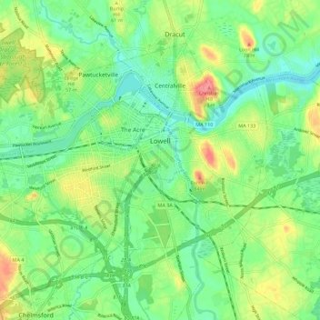
Name: Lowell topographic map, elevation, terrain.
Location: Lowell, Middlesex County, Massachusetts, United States (42.60649 -71.38248 42.66652 -71.27119)
Average elevation: 138 ft
Minimum elevation: 46 ft
Maximum elevation: 344 ft
Middlesex County trails, hiking, mountain biking, running and outdoor activities
Other topographic maps
Click on a map to view its topography, its elevation and its terrain.
Framingham Center
United States > Massachusetts > Middlesex County > Framingham
Average elevation: 190 ft
Medford Hillside
United States > Massachusetts > Middlesex County > Medford > West Medford
Average elevation: 43 ft
North Chelmsford
United States > Massachusetts > Middlesex County > Chelmsford
Average elevation: 135 ft
Winchester Highlands
United States > Massachusetts > Middlesex County > Winchester
Average elevation: 115 ft
Oak Hill
United States > Massachusetts > Middlesex County > Newton
This village is situated on a landform known since the mid-17th century as Oak Hill, and one of the seven principal elevations of Newton (the others being Nonantum Hill, Waban Hill, Chestnut Hill, Bald Pate Hill, Institution Hill, and Mount Ida).
Average elevation: 141 ft
Susan Lawerence Land
United States > Massachusetts > Middlesex County > Stow
Average elevation: 246 ft
Melrose Highlands
United States > Massachusetts > Middlesex County > Melrose
Average elevation: 125 ft
Hobbs Road
United States > Massachusetts > Middlesex County > Wayland > Cochituate
Average elevation: 217 ft
Cambridge
United States > Massachusetts > Middlesex County > Cambridge
Cambridge obtains water from Hobbs Brook (in Lincoln and Waltham) and Stony Brook (Waltham and Weston), as well as an emergency connection to the Massachusetts Water Resources Authority. The city owns over 1,200 acres (486 ha) of land in other towns that includes these reservoirs and portions of their…
Average elevation: 102 ft
Camp Kiwanis
United States > Massachusetts > Middlesex County > Tyngsborough
Average elevation: 217 ft
Arlington Heights
United States > Massachusetts > Middlesex County > Arlington
Average elevation: 190 ft
North Chelmsford
United States > Massachusetts > Middlesex County > Chelmsford
Average elevation: 135 ft
East Acton
United States > Massachusetts > Middlesex County > Acton > East Acton
Average elevation: 174 ft
Weston Station
United States > Massachusetts > Middlesex County > Weston > Weston Station
Average elevation: 180 ft