
Make a donation
Gear up for your next adventure:
As an Amazon Associate, this site earns from qualifying purchases at no extra cost to you.
Sa`dah topographic map
Click on the map to display elevation.
Make a donation
Gear up for your next adventure:
As an Amazon Associate, this site earns from qualifying purchases at no extra cost to you.
Sa`dah
Saada (Arabic: صَعْدَة, romanized: Ṣaʿda), a city and ancient capital in the northwest of Yemen, is the capital and largest city of the province of the same name, and the county seat of the county of the same name. The city is located in the mountains of Serat (Sarawat) at an altitude of about 1,800 meters and had an estimated population of 51,870 in 2004, when it was the tenth largest city in Yemen.[1]
Make a donation
Gear up for your next adventure:
As an Amazon Associate, this site earns from qualifying purchases at no extra cost to you.
About this map
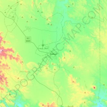
Name: Sa`dah topographic map, elevation, terrain.
Location: Sa`dah, Sa'adah district, Sa'dah Governorate, Yemen (16.78093 43.60303 17.10093 43.92303)
Average elevation: 6,421 ft
Minimum elevation: 5,525 ft
Maximum elevation: 8,707 ft
Make a donation
Gear up for your next adventure:
As an Amazon Associate, this site earns from qualifying purchases at no extra cost to you.