Geolocate

Hverfjall topographic map

Click on the map to display elevation.

About this map

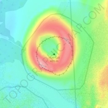
Name: Hverfjall topographic map, elevation, terrain.

Location: Hverfjall, Þingeyjarsveit, Northeastern Region, 660, Iceland (65.60501 -16.87400 65.60511 -16.87390)

Average elevation: 1,083 ft

Minimum elevation: 919 ft

Maximum elevation: 1,444 ft

Other topographic maps

Click on a map to view its topography, its elevation and its terrain.

Mývatn

Iceland > Þingeyjarsveit > Reykjahlíð

Average elevation: 935 ft

Skútustaðagígar

Iceland > Þingeyjarsveit

Average elevation: 919 ft

Stakhólstjörn

Iceland > Þingeyjarsveit

Average elevation: 919 ft

Gear up for your next adventure:

🧥Men's Rain Shells - Premium waterproof and breathable jackets for mountain weather
🏫Relief Map Kits - Hands-on tools for teaching landforms and elevation
🪵Folding Camp Saw - Compact saw for wood and campsite work
🪶Camp Gear Gift Set - Perfect gift bundle for outdoor fans
🛡️Insect Repellent - Protection against bugs during outdoor activities

As an Amazon Associate, this site earns from qualifying purchases at no extra cost to you.