Geolocate

Oneida topographic map

Click on the map to display elevation.

About this map

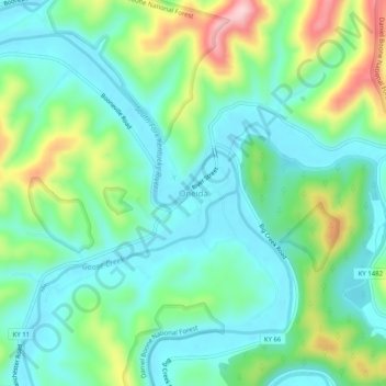
Name: Oneida topographic map, elevation, terrain.

Location: Oneida, Clay County, Kentucky, United States (37.24953 -83.66908 37.28953 -83.62908)

Average elevation: 974 ft

Minimum elevation: 745 ft

Maximum elevation: 1,565 ft

Clay County trails, hiking, mountain biking, running and outdoor activities

Other topographic maps

Click on a map to view its topography, its elevation and its terrain.

Manchester

United States > Kentucky > Clay County

Average elevation: 1,033 ft

Gear up for your next adventure:

🎒Outdoor Daypacks - Lightweight backpacks designed for carrying maps and essential gear
📻Weather Alert Radios - Stay informed of storm risks while off-the-grid
🔊Portable Camp Speaker - Music and alerts at camp
🩳Quick‑Dry Hiking Shorts - Comfortable and quick‑dry shorts for summer hiking
🧭GPS Watch Accessories - Bands and chargers for GPS watches

As an Amazon Associate, this site earns from qualifying purchases at no extra cost to you.