Geolocate

Manchester topographic map

Click on the map to display elevation.

About this map

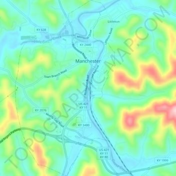
Name: Manchester topographic map, elevation, terrain.

Location: Manchester, Clay County, Kentucky, 40962, United States (37.12780 -83.78244 37.16738 -83.75430)

Average elevation: 1,033 ft

Minimum elevation: 830 ft

Maximum elevation: 1,565 ft

Clay County trails, hiking, mountain biking, running and outdoor activities

Other topographic maps

Click on a map to view its topography, its elevation and its terrain.

Sextons Creek

United States > Kentucky > Clay County

Average elevation: 1,020 ft

Big Creek

United States > Kentucky > Clay County

Average elevation: 1,161 ft

Littleton

United States > Kentucky > Clay County

Average elevation: 1,033 ft

Fall Rock

United States > Kentucky > Clay County

Average elevation: 1,129 ft

Vine

United States > Kentucky > Clay County

Average elevation: 1,099 ft

Gear up for your next adventure:

🛶Inflatable Kayak - Portable kayak for rivers, lakes, and expeditions
🛡️Insect Repellent - Protection against bugs during outdoor activities
📷Action Camera - Capture your outdoor adventures in HD
🧯Emergency Survival Kit - All‑in‑one survival essentials for the backcountry
🥘Titanium Cookware - Durable, featherlight pots and pans for backpacking

As an Amazon Associate, this site earns from qualifying purchases at no extra cost to you.