
Onion Creek topographic map
Interactive map
Click on the map to display elevation.
About this map
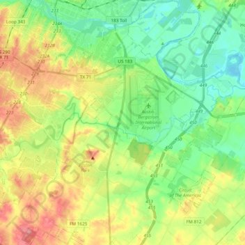
Name: Onion Creek topographic map, elevation, terrain.
Location: Onion Creek, Austin, Travis County, Texas, United States (30.15339 -97.78069 30.20743 -97.58778)
Average elevation: 531 ft
Minimum elevation: 387 ft
Maximum elevation: 784 ft
Travis County trails, hiking, mountain biking, running and outdoor activities
Other topographic maps
Click on a map to view its topography, its elevation and its terrain.
Circle C Ranch Metropolitan Park on Slaughter Creek
United States > Texas > Travis County > Austin
Average elevation: 850 ft
Austin
United States > Texas > Travis County > Austin
The elevation of Austin varies from 425 feet (130 m) to approximately 1,000 feet (305 m) above sea level. Due to the fact it straddles the Balcones Fault, much of the eastern part of the city is flat, with heavy clay and loam soils, whereas the western part and western suburbs consist of rolling hills on the…
Average elevation: 666 ft