
Thank you for supporting this site ❤️
Make a donation
Make a donation
Gear up for your next adventure:
As an Amazon Associate, this site earns from qualifying purchases at no extra cost to you.
Neu-Berich topographic map
Click on the map to display elevation.
Thank you for supporting this site ❤️
Make a donation
Make a donation
Gear up for your next adventure:
As an Amazon Associate, this site earns from qualifying purchases at no extra cost to you.
Neu-Berich
Neben Berich wurden auch die ursprünglich im Tal der Eder liegenden Dörfer Asel und Bringhausen sowie drei Einzelgehöfte umgesiedelt und an höher gelegenen Stellen oberhalb des damals entstehenden Edersees neu errichtet.
Thank you for supporting this site ❤️
Make a donation
Make a donation
Gear up for your next adventure:
As an Amazon Associate, this site earns from qualifying purchases at no extra cost to you.
About this map
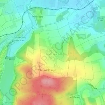
Name: Neu-Berich topographic map, elevation, terrain.
Average elevation: 741 ft
Minimum elevation: 597 ft
Maximum elevation: 988 ft
Thank you for supporting this site ❤️
Make a donation
Make a donation
Gear up for your next adventure:
As an Amazon Associate, this site earns from qualifying purchases at no extra cost to you.