
Thank you for supporting this site ❤️
Make a donation
Make a donation
Gear up for your next adventure:
As an Amazon Associate, this site earns from qualifying purchases at no extra cost to you.
Pinehurst topographic map
Click on the map to display elevation.
Thank you for supporting this site ❤️
Make a donation
Make a donation
Gear up for your next adventure:
As an Amazon Associate, this site earns from qualifying purchases at no extra cost to you.
About this map
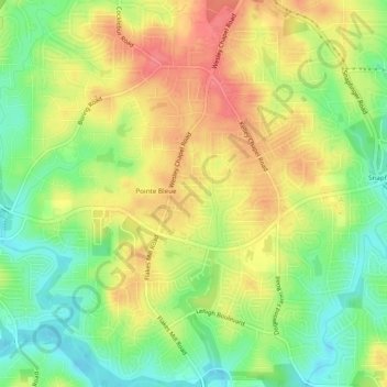
Name: Pinehurst topographic map, elevation, terrain.
Location: Pinehurst, DeKalb County, Georgia, 30034-5209, United States (33.66539 -84.24548 33.70539 -84.20548)
Average elevation: 843 ft
Minimum elevation: 728 ft
Maximum elevation: 958 ft
Thank you for supporting this site ❤️
Make a donation
Make a donation
Gear up for your next adventure:
As an Amazon Associate, this site earns from qualifying purchases at no extra cost to you.