
Thank you for supporting this site ❤️
Make a donation
Make a donation
Gear up for your next adventure:
As an Amazon Associate, this site earns from qualifying purchases at no extra cost to you.
Ribeira topographic map
Click on the map to display elevation.
Thank you for supporting this site ❤️
Make a donation
Make a donation
Gear up for your next adventure:
As an Amazon Associate, this site earns from qualifying purchases at no extra cost to you.
About this map
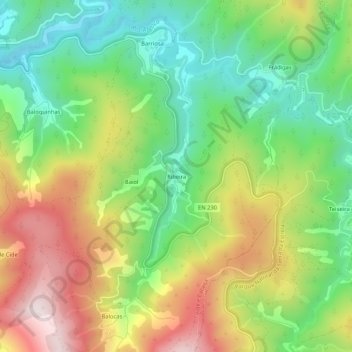
Name: Ribeira topographic map, elevation, terrain.
Location: Ribeira, Vide e Cabeça, Seia, Guarda, 6285-052, Portugal (40.25729 -7.77357 40.29729 -7.73357)
Average elevation: 1,821 ft
Minimum elevation: 981 ft
Maximum elevation: 2,982 ft
Thank you for supporting this site ❤️
Make a donation
Make a donation
Gear up for your next adventure:
As an Amazon Associate, this site earns from qualifying purchases at no extra cost to you.