
Make a donation
Gear up for your next adventure:
As an Amazon Associate, this site earns from qualifying purchases at no extra cost to you.
Landrum Watershed topographic map
Click on the map to display elevation.
Make a donation
Gear up for your next adventure:
As an Amazon Associate, this site earns from qualifying purchases at no extra cost to you.
About this map
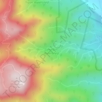
Name: Landrum Watershed topographic map, elevation, terrain.
Average elevation: 2,106 ft
Minimum elevation: 1,191 ft
Maximum elevation: 3,219 ft
Greenville County trails, hiking, mountain biking, running and outdoor activities
Make a donation
Gear up for your next adventure:
As an Amazon Associate, this site earns from qualifying purchases at no extra cost to you.
Other topographic maps
Click on a map to view its topography, its elevation and its terrain.
Make a donation
Gear up for your next adventure:
As an Amazon Associate, this site earns from qualifying purchases at no extra cost to you.
Marietta
United States > South Carolina > Greenville County > Slater-Marietta
Average elevation: 1,040 ft
Make a donation
Gear up for your next adventure:
As an Amazon Associate, this site earns from qualifying purchases at no extra cost to you.
Isaqueena Park
United States > South Carolina > Greenville County > Greenville
Average elevation: 974 ft
Make a donation
Gear up for your next adventure:
As an Amazon Associate, this site earns from qualifying purchases at no extra cost to you.
Cleveland Forest
United States > South Carolina > Greenville County > Greenville
Average elevation: 942 ft
Make a donation
Gear up for your next adventure:
As an Amazon Associate, this site earns from qualifying purchases at no extra cost to you.
Sherwood Forest
United States > South Carolina > Greenville County > Greenville
Average elevation: 961 ft
Little Table Rock Mountain
United States > South Carolina > Greenville County
Average elevation: 2,927 ft
Make a donation
Gear up for your next adventure:
As an Amazon Associate, this site earns from qualifying purchases at no extra cost to you.
Mount Vernon Estates
United States > South Carolina > Greenville County > Greer
Average elevation: 991 ft
Orchard Acres
United States > South Carolina > Greenville County > Wade Hampton
Average elevation: 958 ft
Piney Ridge
United States > South Carolina > Greenville County > Wade Hampton
Average elevation: 997 ft
Make a donation
Gear up for your next adventure:
As an Amazon Associate, this site earns from qualifying purchases at no extra cost to you.
Crescentwood Village
United States > South Carolina > Greenville County > Mauldin
Average elevation: 906 ft
Make a donation
Gear up for your next adventure:
As an Amazon Associate, this site earns from qualifying purchases at no extra cost to you.
Morningside
United States > South Carolina > Greenville County > Wade Hampton
Average elevation: 984 ft
Evergreen Place
United States > South Carolina > Greenville County > Greenville
Average elevation: 945 ft
Make a donation
Gear up for your next adventure:
As an Amazon Associate, this site earns from qualifying purchases at no extra cost to you.
Make a donation
Gear up for your next adventure:
As an Amazon Associate, this site earns from qualifying purchases at no extra cost to you.
Glenwood Acres
United States > South Carolina > Greenville County > Greenville
Average elevation: 1,001 ft
Stone Lake
United States > South Carolina > Greenville County > Greenville
Average elevation: 1,001 ft