Geolocate

Marietta topographic map

Click on the map to display elevation.

About this map

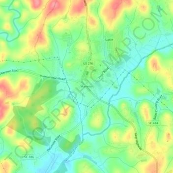
Name: Marietta topographic map, elevation, terrain.

Location: Marietta, Slater-Marietta, Greenville County, South Carolina, 29683, United States (35.00095 -82.52151 35.04095 -82.48151)

Average elevation: 1,040 ft

Minimum elevation: 922 ft

Maximum elevation: 1,217 ft

Greenville County trails, hiking, mountain biking, running and outdoor activities

Other topographic maps

Click on a map to view its topography, its elevation and its terrain.

Gear up for your next adventure:

🎒Waterproof Dry Bags - Keep your electronics and maps dry inside your pack
🌄Hiking Binoculars - Compact binoculars for scenic views and trail spotting
🥾Women's Hiking Boots - Top-rated trail boots with ankle support and superior grip
🎒Gear Packing Cubes - Organize your backpack efficiently
🔭Telescopic Hiking Pole - Adjustable pole for hiking stability

As an Amazon Associate, this site earns from qualifying purchases at no extra cost to you.