Geolocate

Atenas topographic map

Click on the map to display elevation.

About this map

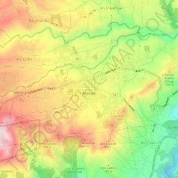
Name: Atenas topographic map, elevation, terrain.

Location: Atenas, Cantón Atenas, Provincia Alajuela, 20501, Costa Rica (9.96027 -84.39608 9.99687 -84.34101)

Average elevation: 2,238 ft

Minimum elevation: 1,234 ft

Maximum elevation: 3,186 ft

Gear up for your next adventure:

🔥Fast-Boil Camping Stoves - Efficient cooking systems for quick trail meals
🎒Gear Packing Cubes - Organize your backpack efficiently
🔋Rechargeable Batteries - Power up your outdoor devices
🪑Ultralight Camp Chairs - Portable seating for resting after a long day of mapping
🩹Survival Bandages - High‑quality bandages for emergencies

As an Amazon Associate, this site earns from qualifying purchases at no extra cost to you.