
Make a donation
Gear up for your next adventure:
As an Amazon Associate, this site earns from qualifying purchases at no extra cost to you.
Neversfelde topographic map
Click on the map to display elevation.
Make a donation
Gear up for your next adventure:
As an Amazon Associate, this site earns from qualifying purchases at no extra cost to you.
About this map
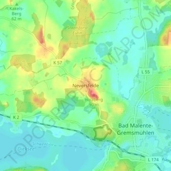
Name: Neversfelde topographic map, elevation, terrain.
Average elevation: 128 ft
Minimum elevation: 66 ft
Maximum elevation: 266 ft
Make a donation
Gear up for your next adventure:
As an Amazon Associate, this site earns from qualifying purchases at no extra cost to you.
Other topographic maps
Click on a map to view its topography, its elevation and its terrain.
Kellersee
Deutschland > Schleswig-Holstein > Ostholstein > Malente > Krummsee
Der ungleichmäßig geformte See hat bei einer Länge von ungefähr 3,2 km und einer Breite von 3,7 km eine Wasseroberfläche von 555 ha, eine Tiefe von bis zu 25,8 m, wobei der Durchschnitt bei 11,7 m liegt, und eine Höhe über dem Meeresspiegel von etwa 24 m.[1]
Average elevation: 108 ft