
Make a donation
Gear up for your next adventure:
As an Amazon Associate, this site earns from qualifying purchases at no extra cost to you.
Plymouth topographic map
Click on the map to display elevation.
Make a donation
Gear up for your next adventure:
As an Amazon Associate, this site earns from qualifying purchases at no extra cost to you.
Plymouth
In 1919, Nancy Astor was elected the first-ever female member of parliament to take office in the British Houses of Parliament for the constituency of Plymouth Sutton. She was elected to the seat vacated by her husband Waldorf Astor on his elevation to the peerage. Lady Astor was a vibrantly active campaigner for her resident constituents.
Make a donation
Gear up for your next adventure:
As an Amazon Associate, this site earns from qualifying purchases at no extra cost to you.
About this map
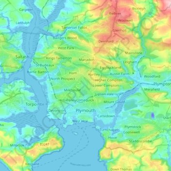
Name: Plymouth topographic map, elevation, terrain.
Location: Plymouth, England, United Kingdom (50.33274 -4.20553 50.44417 -4.01961)
Average elevation: 151 ft
Minimum elevation: -125 ft
Maximum elevation: 653 ft
Make a donation
Gear up for your next adventure:
As an Amazon Associate, this site earns from qualifying purchases at no extra cost to you.
Other topographic maps
Click on a map to view its topography, its elevation and its terrain.
Make a donation
Gear up for your next adventure:
As an Amazon Associate, this site earns from qualifying purchases at no extra cost to you.
Coalville
United Kingdom > England > Leicestershire > North West Leicestershire
Average elevation: 489 ft
Make a donation
Gear up for your next adventure:
As an Amazon Associate, this site earns from qualifying purchases at no extra cost to you.
Make a donation
Gear up for your next adventure:
As an Amazon Associate, this site earns from qualifying purchases at no extra cost to you.
Make a donation
Gear up for your next adventure:
As an Amazon Associate, this site earns from qualifying purchases at no extra cost to you.
Make a donation
Gear up for your next adventure:
As an Amazon Associate, this site earns from qualifying purchases at no extra cost to you.
Make a donation
Gear up for your next adventure:
As an Amazon Associate, this site earns from qualifying purchases at no extra cost to you.