Geolocate

Desnianskyi district topographic map

Click on the map to display elevation.

About this map

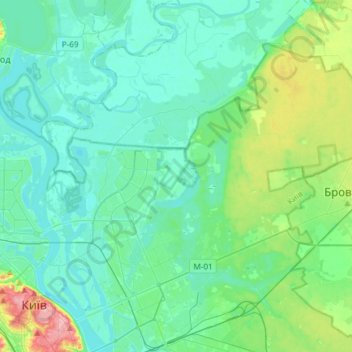
Name: Desnianskyi district topographic map, elevation, terrain.

Location: Desnianskyi district, Kyiv, Ukraine (50.44734 30.52540 50.59081 30.82335)

Average elevation: 361 ft

Minimum elevation: 285 ft

Maximum elevation: 689 ft

Other topographic maps

Click on a map to view its topography, its elevation and its terrain.

Пронівщина

Ukraine > Kyiv

Average elevation: 571 ft

Gear up for your next adventure:

🧭Orienteering Set - Complete compass and map reading kit
💧Water Purification System - Clean water on the trail with reliable purifiers
🪄Magnetic Compass - Accurate compass for navigation
Backpacking Tent - Lightweight and durable tent for multi‑day hikes
Camping Coffee Makers - Enjoy premium coffee at the summit or campsite

As an Amazon Associate, this site earns from qualifying purchases at no extra cost to you.