Geolocate

Baramulla topographic map

Click on the map to display elevation.

Baramulla

Baramulla is located at 34.2° N 74.34° E. It has an average elevation of 1,593 meters (5,226 feet).

Wikipedia (CC-BY-SA 3.0)

About this map

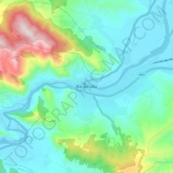
Name: Baramulla topographic map, elevation, terrain.

Location: Baramulla, Jammu and Kashmir, 193101, India (34.04869 74.18350 34.36869 74.50350)

Average elevation: 6,460 ft

Minimum elevation: 4,708 ft

Maximum elevation: 12,487 ft

Gear up for your next adventure:

🛰️Handheld GPS Units - Professional satellite navigators for precise backcountry mapping
🥤Water Filter Bottle - All‑in‑one filter bottle for safe hydration
🚁Photography Drones - Capture stunning aerial views of landforms and topography
🦶Hiking Gaiters - Keep debris and water out of your boots
🔭Compact Binoculars - HD vision for scouting terrain and identifying distant landmarks

As an Amazon Associate, this site earns from qualifying purchases at no extra cost to you.