
Make a donation
Gear up for your next adventure:
As an Amazon Associate, this site earns from qualifying purchases at no extra cost to you.
Westende-Bad topographic map
Click on the map to display elevation.
Make a donation
Gear up for your next adventure:
As an Amazon Associate, this site earns from qualifying purchases at no extra cost to you.
About this map
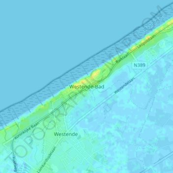
Name: Westende-Bad topographic map, elevation, terrain.
Average elevation: 7 ft
Minimum elevation: -13 ft
Maximum elevation: 66 ft
Make a donation
Gear up for your next adventure:
As an Amazon Associate, this site earns from qualifying purchases at no extra cost to you.
Other topographic maps
Click on a map to view its topography, its elevation and its terrain.
Sint-Pieters-Kapelle
België > West-Vlaanderen > Oostende > Middelkerke
Sint-Pieters-Kapelle ligt in het West-Vlaamse poldergebied op een hoogte van ongeveer 2 meter. Enkele waterlopen zijn het Spermaliegeleed en de Lekevaart.
Average elevation: 3 ft
Make a donation
Gear up for your next adventure:
As an Amazon Associate, this site earns from qualifying purchases at no extra cost to you.
Leffinge
België > West-Vlaanderen > Oostende > Middelkerke
In de oorlog 1914-1918 wordt het klooster opgeëist door de Duitse bezetter die van het klooster met zijn panoramisch gezicht zijn uitkijkpost maakt. Het strategische belang van het klooster en ook het feit dat er hoge Duitse officieren gelegerd zijn, maken dat het klooster – door de geallieerden gekend…
Average elevation: 3 ft