
Make a donation
Gear up for your next adventure:
As an Amazon Associate, this site earns from qualifying purchases at no extra cost to you.
Quirieu topographic map
Click on the map to display elevation.
Make a donation
Gear up for your next adventure:
As an Amazon Associate, this site earns from qualifying purchases at no extra cost to you.
Quirieu
Bouvesse-Quirieu est une modeste commune rurale située dans une région de collines. Le bourg s'élève à une altitude de 220 m et se positionne à environ 30 km au nord-est de Bourgoin-Jallieu, dans la partie septentrionale du département de l'Isère. La commune est bordée à l'est par le Rhône qui la sépare du département de l'Ain.
Make a donation
Gear up for your next adventure:
As an Amazon Associate, this site earns from qualifying purchases at no extra cost to you.
About this map
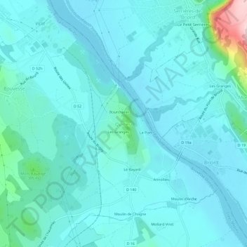
Name: Quirieu topographic map, elevation, terrain.
Average elevation: 768 ft
Minimum elevation: 650 ft
Maximum elevation: 1,621 ft
Make a donation
Gear up for your next adventure:
As an Amazon Associate, this site earns from qualifying purchases at no extra cost to you.
Other topographic maps
Click on a map to view its topography, its elevation and its terrain.
Lac Dauphin
France > Auvergne-Rhône-Alpes > Isère > Bouvesse-Quirieu > Quirieu > Les Granges
Average elevation: 771 ft