
Thank you for supporting this site ❤️
Make a donation
Make a donation
Gear up for your next adventure:
As an Amazon Associate, this site earns from qualifying purchases at no extra cost to you.
Santiago topographic map
Click on the map to display elevation.
Thank you for supporting this site ❤️
Make a donation
Make a donation
Gear up for your next adventure:
As an Amazon Associate, this site earns from qualifying purchases at no extra cost to you.
About this map
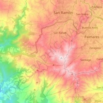
Name: Santiago topographic map, elevation, terrain.
Location: Santiago, Cantón de San Ramón, Alajuela, 20202, Costa Rica (9.99295 -84.60895 10.08311 -84.47341)
Average elevation: 3,097 ft
Minimum elevation: 830 ft
Maximum elevation: 4,987 ft
Thank you for supporting this site ❤️
Make a donation
Make a donation
Gear up for your next adventure:
As an Amazon Associate, this site earns from qualifying purchases at no extra cost to you.
Other topographic maps
Click on a map to view its topography, its elevation and its terrain.
Río Jesús
Costa Rica > Alajuela > Cantón de San Ramón > San Rafael > Berlín
Average elevation: 4,091 ft