
Make a donation
Gear up for your next adventure:
As an Amazon Associate, this site earns from qualifying purchases at no extra cost to you.
La Varenne topographic map
Click on the map to display elevation.
Make a donation
Gear up for your next adventure:
As an Amazon Associate, this site earns from qualifying purchases at no extra cost to you.
About this map
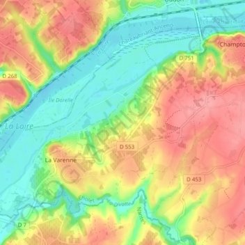
Name: La Varenne topographic map, elevation, terrain.
Average elevation: 135 ft
Minimum elevation: -3 ft
Maximum elevation: 276 ft
Make a donation
Gear up for your next adventure:
As an Amazon Associate, this site earns from qualifying purchases at no extra cost to you.
Other topographic maps
Click on a map to view its topography, its elevation and its terrain.
Les Petites Bourgères
France > Pays de la Loire > Maine-et-Loire > Orée d'Anjou
Average elevation: 325 ft
Make a donation
Gear up for your next adventure:
As an Amazon Associate, this site earns from qualifying purchases at no extra cost to you.
Saint-Sauveur-de-Landemont
France > Pays de la Loire > Maine-et-Loire > Orée d'Anjou
Average elevation: 233 ft
Le Moulin Gasselin
France > Pays de la Loire > Maine-et-Loire > Orée d'Anjou
Average elevation: 161 ft
Make a donation
Gear up for your next adventure:
As an Amazon Associate, this site earns from qualifying purchases at no extra cost to you.
Château de la Turmelière
France > Pays de la Loire > Maine-et-Loire > Orée d'Anjou
Average elevation: 151 ft
Make a donation
Gear up for your next adventure:
As an Amazon Associate, this site earns from qualifying purchases at no extra cost to you.