Geolocate

Flaring topographic map

Click on the map to display elevation.

About this map

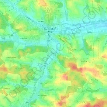
Name: Flaring topographic map, elevation, terrain.

Location: Flaring, Taufkirchen, Landkreis Erding, Bayern, 84416, Deutschland (48.31552 12.11310 48.35552 12.15310)

Average elevation: 1,591 ft

Minimum elevation: 1,503 ft

Maximum elevation: 1,729 ft

Other topographic maps

Click on a map to view its topography, its elevation and its terrain.

84416

Deutschland > Bayern > Landkreis Erding > Taufkirchen > Aham > Hilpolding

Average elevation: 1,591 ft

Gear up for your next adventure:

🛠️Outdoor Gear Repair Kit - Essential tools to fix gear on the trail
🍳Camping Cook Set - Complete cookware for outdoor meals
🌡️Handheld Weather Meters - Measure wind, temp, and pressure for safe mountain travel
🚪Portable Camp Chair - Foldable chair for comfort at camp
🌐World Map Poster - Decorative world maps with topographic info

As an Amazon Associate, this site earns from qualifying purchases at no extra cost to you.