Geolocate

Karlstad topographic map

Click on the map to display elevation.

About this map

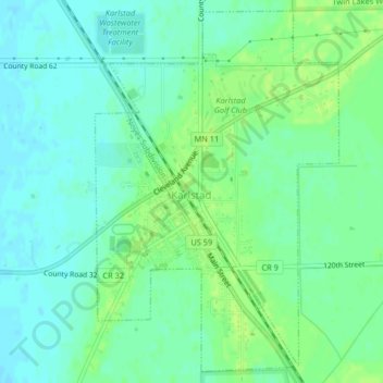
Name: Karlstad topographic map, elevation, terrain.

Location: Karlstad, Kittson County, Minnesota, United States (48.56503 -96.52923 48.59050 -96.50319)

Average elevation: 1,040 ft

Minimum elevation: 1,020 ft

Maximum elevation: 1,060 ft

Kittson County trails, hiking, mountain biking, running and outdoor activities

Other topographic maps

Click on a map to view its topography, its elevation and its terrain.

Noyes

United States > Minnesota > Kittson County

Average elevation: 791 ft

Noyes

United States > Minnesota > Kittson County

Average elevation: 791 ft

Gear up for your next adventure:

🧥Men's Rain Shells - Premium waterproof and breathable jackets for mountain weather
Camping Coffee Makers - Enjoy premium coffee at the summit or campsite
👓Polarized Sunglasses - Outdoor sunglasses for glare reduction
🧺Microfiber Travel Towels - Compact and fast-drying towels for trail use
📷Action Cameras - Rugged cameras to document your journeys across rugged terrain

As an Amazon Associate, this site earns from qualifying purchases at no extra cost to you.