
Chertsey topographic map
Click on the map to display elevation.
Chertsey
Samuel Lewis devotes one of his longest entries to the small town in his 1848 topographical guide to England.
About this map
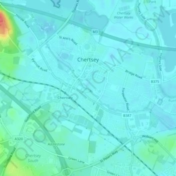
Name: Chertsey topographic map, elevation, terrain.
Average elevation: 56 ft
Minimum elevation: 30 ft
Maximum elevation: 217 ft
Other topographic maps
Click on a map to view its topography, its elevation and its terrain.
Cooper's Hill Slopes
United Kingdom > England > Surrey > Borough of Runnymede > Englefield Green
Average elevation: 125 ft
Chertsey
United Kingdom > England > Surrey > Borough of Runnymede
Samuel Lewis devotes one of his longest entries to the small town in his 1848 topographical guide to England.
Average elevation: 72 ft
Egham Wick
United Kingdom > England > Surrey > Borough of Runnymede > Englefield Green
Average elevation: 180 ft
Lyn Mushroom Farm
United Kingdom > England > Surrey > Borough of Runnymede > Lyne
Average elevation: 128 ft
Chertsey
United Kingdom > England > Surrey > Borough of Runnymede
Samuel Lewis devotes one of his longest entries to the small town in his 1848 topographical guide to England.
Average elevation: 72 ft