
Make a donation
Gear up for your next adventure:
As an Amazon Associate, this site earns from qualifying purchases at no extra cost to you.
Charles Mound topographic map
Click on the map to display elevation.
Make a donation
Gear up for your next adventure:
As an Amazon Associate, this site earns from qualifying purchases at no extra cost to you.
About this map
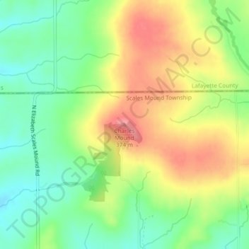
Name: Charles Mound topographic map, elevation, terrain.
Average elevation: 1,070 ft
Minimum elevation: 935 ft
Maximum elevation: 1,224 ft
Make a donation
Gear up for your next adventure:
As an Amazon Associate, this site earns from qualifying purchases at no extra cost to you.
Other topographic maps
Click on a map to view its topography, its elevation and its terrain.
Make a donation
Gear up for your next adventure:
As an Amazon Associate, this site earns from qualifying purchases at no extra cost to you.
Stockton
United States > Illinois > Jo Daviess County
The village water tower sits on a ridge at elevation 1,105 ft (337 m) that rises to 1,120 ft (340 m) to the west at the village limits. To the northwest the same ridge line continues where U.S. Route 20 crests at 1,077 ft (328 m) just to the west. This ridge line continues for 3 miles to the northwest to…
Average elevation: 988 ft
Make a donation
Gear up for your next adventure:
As an Amazon Associate, this site earns from qualifying purchases at no extra cost to you.
Scales Mound
United States > Illinois > Jo Daviess County
Scales Mound is located in a region of the U.S. Midwest known as the Driftless Area, so called because it escaped glaciation during the last ice age. It covers parts of Illinois, Wisconsin, Minnesota and Iowa. The Illinois section is mostly limited to Jo Daviess County and small parts of Whiteside and Carroll…
Average elevation: 965 ft