
Make a donation
Gear up for your next adventure:
As an Amazon Associate, this site earns from qualifying purchases at no extra cost to you.
Inazares topographic map
Click on the map to display elevation.
Make a donation
Gear up for your next adventure:
As an Amazon Associate, this site earns from qualifying purchases at no extra cost to you.
Inazares
Inazares es una pedanía del término municipal de Moratalla (Murcia), España. Se encuentra a 1.350 m de altitud debido a su cercanía con el Macizo de Revolcadores y la Sierra de Villafuerte, siendo la pedanía situada a mayor altura de la Región de Murcia. Otras localidades cercanas son Cañada de la Cruz, Tartamudo de Abajo y Tartamudo de Arriba.
Make a donation
Gear up for your next adventure:
As an Amazon Associate, this site earns from qualifying purchases at no extra cost to you.
About this map
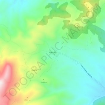
Name: Inazares topographic map, elevation, terrain.
Location: Inazares, Moratalla, Noroeste, Región de Murcia, España (38.06086 -2.23089 38.10086 -2.19089)
Average elevation: 4,636 ft
Minimum elevation: 3,967 ft
Maximum elevation: 5,997 ft
Make a donation
Gear up for your next adventure:
As an Amazon Associate, this site earns from qualifying purchases at no extra cost to you.
Other topographic maps
Click on a map to view its topography, its elevation and its terrain.