Geolocate

Cordova topographic map

Click on the map to display elevation.

About this map

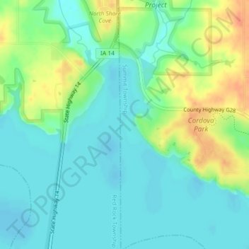
Name: Cordova topographic map, elevation, terrain.

Location: Cordova, Summit Township, Marion County, Iowa, United States (41.41756 -93.10966 41.43756 -93.08966)

Average elevation: 771 ft

Minimum elevation: 722 ft

Maximum elevation: 869 ft

Other topographic maps

Click on a map to view its topography, its elevation and its terrain.

Knoxville

United States > Iowa > Marion County

Average elevation: 869 ft

Pella

United States > Iowa > Marion County

Average elevation: 833 ft

Gear up for your next adventure:

🪶Survival Guide Book - Expert advice for emergency preparedness
🪑Ultralight Camp Chairs - Portable seating for resting after a long day of mapping
🛶Inflatable Kayak - Portable kayak for rivers, lakes, and expeditions
🎒Day Hiking Backpack - Lightweight backpack perfect for day trips and outdoor adventures
🎒Gear Packing Cubes - Organize your backpack efficiently

As an Amazon Associate, this site earns from qualifying purchases at no extra cost to you.