
Thank you for supporting this site ❤️
Make a donation
Make a donation
Gear up for your next adventure:
As an Amazon Associate, this site earns from qualifying purchases at no extra cost to you.
Les Trois-Îlets topographic map
Click on the map to display elevation.
Thank you for supporting this site ❤️
Make a donation
Make a donation
Gear up for your next adventure:
As an Amazon Associate, this site earns from qualifying purchases at no extra cost to you.
About this map
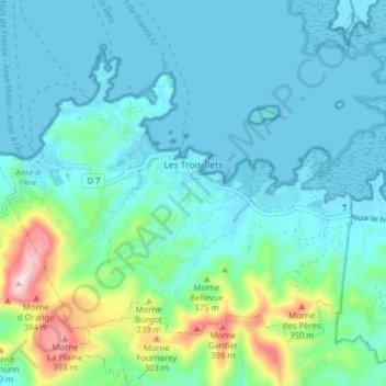
Name: Les Trois-Îlets topographic map, elevation, terrain.
Location: Les Trois-Îlets, Le Marin, Martinica, 97229, Francia (14.50352 -61.07991 14.56226 -61.00113)
Average elevation: 259 ft
Minimum elevation: -10 ft
Maximum elevation: 1,453 ft
Thank you for supporting this site ❤️
Make a donation
Make a donation
Gear up for your next adventure:
As an Amazon Associate, this site earns from qualifying purchases at no extra cost to you.