
Thank you for supporting this site ❤️
Make a donation
Make a donation
Gear up for your next adventure:
As an Amazon Associate, this site earns from qualifying purchases at no extra cost to you.
Hippbichl topographic map
Click on the map to display elevation.
Thank you for supporting this site ❤️
Make a donation
Make a donation
Gear up for your next adventure:
As an Amazon Associate, this site earns from qualifying purchases at no extra cost to you.
About this map
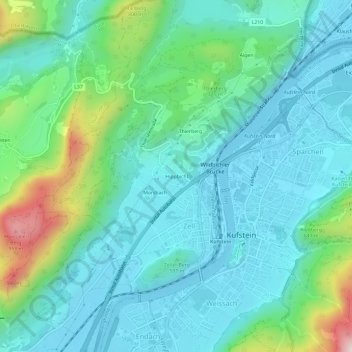
Name: Hippbichl topographic map, elevation, terrain.
Location: Hippbichl, Kufstein, Bezirk Kufstein, Tirol, 6330, Österreich (47.56968 12.13829 47.60968 12.17829)
Average elevation: 1,962 ft
Minimum elevation: 1,565 ft
Maximum elevation: 3,432 ft
Thank you for supporting this site ❤️
Make a donation
Make a donation
Gear up for your next adventure:
As an Amazon Associate, this site earns from qualifying purchases at no extra cost to you.
Other topographic maps
Click on a map to view its topography, its elevation and its terrain.