
Make a donation
Gear up for your next adventure:
As an Amazon Associate, this site earns from qualifying purchases at no extra cost to you.
Halde Hoppenbruch topographic map
Click on the map to display elevation.
Make a donation
Gear up for your next adventure:
As an Amazon Associate, this site earns from qualifying purchases at no extra cost to you.
Halde Hoppenbruch
Die Halde Hoppenbruch ist eine Bergehalde an der Straße Im Emscherbruch in Herten. Sie entstand zwischen 1978 und 1992 aus Aufschüttungen der Zechen Ewald/Schlägel & Eisen und General Blumenthal/Haard und hat ein Volumen von 34 Millionen Tonnen bei einer Höhe von etwas mehr als 70 Metern über dem Umgebungsniveau. Ab 1983 war sie der Öffentlichkeit teilweise zugänglich, seit 1992 aus der Bergaufsicht entlassen und vollständig geöffnet. Von oben hat man einen weiten Blick über das Ruhrgebiet.
Make a donation
Gear up for your next adventure:
As an Amazon Associate, this site earns from qualifying purchases at no extra cost to you.
About this map
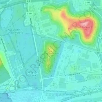
Name: Halde Hoppenbruch topographic map, elevation, terrain.
Average elevation: 180 ft
Minimum elevation: 102 ft
Maximum elevation: 499 ft
Make a donation
Gear up for your next adventure:
As an Amazon Associate, this site earns from qualifying purchases at no extra cost to you.
Other topographic maps
Click on a map to view its topography, its elevation and its terrain.
Bertlich
Deutschland > Nordrhein-Westfalen > Kreis Recklinghausen > Herten > Westerholt
Average elevation: 230 ft
Scherlebeck
Deutschland > Nordrhein-Westfalen > Kreis Recklinghausen > Herten
Average elevation: 285 ft
45701
Deutschland > Nordrhein-Westfalen > Kreis Recklinghausen > Herten > Westerholt
Average elevation: 246 ft
Make a donation
Gear up for your next adventure:
As an Amazon Associate, this site earns from qualifying purchases at no extra cost to you.
Bertlich
Deutschland > Nordrhein-Westfalen > Kreis Recklinghausen > Herten > Westerholt
Average elevation: 230 ft