Geolocate

San Roque topographic map

Click on the map to display elevation.

About this map

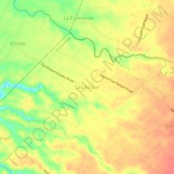
Name: San Roque topographic map, elevation, terrain.

Location: San Roque, Kidapawan, Cotabato, Soccsksargen, Philippines (7.07902 124.96908 7.11902 125.00908)

Average elevation: 285 ft

Minimum elevation: 167 ft

Maximum elevation: 354 ft

Other topographic maps

Click on a map to view its topography, its elevation and its terrain.

Pulangi River

Philippines > Cotabato > Kidapawan

Average elevation: 1,444 ft

Gear up for your next adventure:

🪶Survival Guide Book - Expert advice for emergency preparedness
🕶️GPS Smartphone Mount - Secure mount for phone navigation
🧼Biodegradable Camping Soap - Eco‑friendly soap for outdoor hygiene
🧴Hand Sanitizer - Keep hands clean while hiking
🧭Map Reading Tools - Tools and kits for map navigation

As an Amazon Associate, this site earns from qualifying purchases at no extra cost to you.