
Make a donation
Gear up for your next adventure:
As an Amazon Associate, this site earns from qualifying purchases at no extra cost to you.
Wilmsdorf topographic map
Click on the map to display elevation.
Make a donation
Gear up for your next adventure:
As an Amazon Associate, this site earns from qualifying purchases at no extra cost to you.
About this map
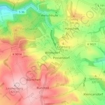
Name: Wilmsdorf topographic map, elevation, terrain.
Average elevation: 1,050 ft
Minimum elevation: 676 ft
Maximum elevation: 1,394 ft
Make a donation
Gear up for your next adventure:
As an Amazon Associate, this site earns from qualifying purchases at no extra cost to you.
Other topographic maps
Click on a map to view its topography, its elevation and its terrain.
Saxon Switzerland National Park
Germany > Saxony > Sächsische Schweiz-Osterzgebirge
Average elevation: 1,168 ft
Make a donation
Gear up for your next adventure:
As an Amazon Associate, this site earns from qualifying purchases at no extra cost to you.
Sebnitz
Germany > Saxony > Sächsische Schweiz-Osterzgebirge
The town of Sebnitz lies in the valley of the river Sebnitz and its side valleys between 251 and 460 m above sea level between the mountains of Saxon Switzerland and the Lusatian Highlands. Topographically the town itself lies in the West Lusatian Upland, but lies right on the border with the Upper Lusatian…
Average elevation: 1,122 ft
Saxon Switzerland
Germany > Saxony > Sächsische Schweiz-Osterzgebirge
Saxon Switzerland forms the northern part of the Elbe Sandstone Mountains range, located on the German-Czech border. To the east, it transitions into the Lusatian Highlands and, to the west, into the Ore Mountains. The Czech part of the Elbe Sandstone Mountains is partly formed by the Bohemian Switzerland…
Average elevation: 1,119 ft
Make a donation
Gear up for your next adventure:
As an Amazon Associate, this site earns from qualifying purchases at no extra cost to you.
01844
Germany > Saxony > Sächsische Schweiz-Osterzgebirge > Neustadt in Sachsen
Average elevation: 1,266 ft
Make a donation
Gear up for your next adventure:
As an Amazon Associate, this site earns from qualifying purchases at no extra cost to you.