Geolocate

Banja Luka topographic map

Click on the map to display elevation.

About this map

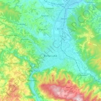
Name: Banja Luka topographic map, elevation, terrain.

Location: Banja Luka, City of Banja Luka, Republika Srpska, Bosnia and Herzegovina (44.71710 17.10902 44.84014 17.30301)

Average elevation: 968 ft

Minimum elevation: 440 ft

Maximum elevation: 2,402 ft

Other topographic maps

Click on a map to view its topography, its elevation and its terrain.

Gear up for your next adventure:

🚪Portable Camp Chair - Foldable chair for comfort at camp
🛏️Cold Weather Sleeping Bag - Warm sleeping bag for cold conditions
⛑️Personal Locator Beacon - Safety beacon for emergencies
🪶Trail Camera - Capture wildlife on your hikes
🛌Ultralight Sleeping Bags - Compact down bags for cold nights in the wilderness

As an Amazon Associate, this site earns from qualifying purchases at no extra cost to you.