Geolocate

Windhoek topographic map

Click on the map to display elevation.

About this map

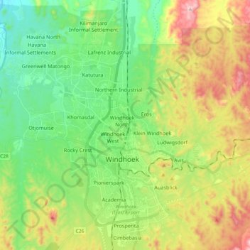
Name: Windhoek topographic map, elevation, terrain.

Location: Windhoek, Khomas, Namibia (-22.63857 17.00429 -22.47083 17.13015)

Average elevation: 5,620 ft

Minimum elevation: 4,915 ft

Maximum elevation: 6,919 ft

Gear up for your next adventure:

🛰️Satellite Messengers - Emergency SOS and two-way messaging for off-grid adventures
🔌USB Car Charger - Car charger for on‑the‑go power needs
🔋Solar Power Banks - Keep your GPS and phone charged in remote wilderness areas
📚USA Hiking Guide Books - Top trail guides and map books
📡GPS Antenna Upgrade - Enhance GPS reception in remote terrain

As an Amazon Associate, this site earns from qualifying purchases at no extra cost to you.