
Make a donation
Gear up for your next adventure:
As an Amazon Associate, this site earns from qualifying purchases at no extra cost to you.
Maitencillo topographic map
Click on the map to display elevation.
Make a donation
Gear up for your next adventure:
As an Amazon Associate, this site earns from qualifying purchases at no extra cost to you.
About this map
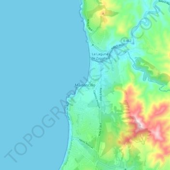
Name: Maitencillo topographic map, elevation, terrain.
Average elevation: 243 ft
Minimum elevation: -3 ft
Maximum elevation: 1,453 ft
Make a donation
Gear up for your next adventure:
As an Amazon Associate, this site earns from qualifying purchases at no extra cost to you.
Other topographic maps
Click on a map to view its topography, its elevation and its terrain.
Isla San Félix
Chile > Valparaiso Region > Provincia de Valparaíso > Valparaíso > Isla San Félix
Average elevation: 33 ft
Make a donation
Gear up for your next adventure:
As an Amazon Associate, this site earns from qualifying purchases at no extra cost to you.
Make a donation
Gear up for your next adventure:
As an Amazon Associate, this site earns from qualifying purchases at no extra cost to you.
Playa Laguna Verde
Chile > Valparaiso Region > Provincia de Valparaíso > Valparaíso > Laguna Verde
Average elevation: 230 ft
Make a donation
Gear up for your next adventure:
As an Amazon Associate, this site earns from qualifying purchases at no extra cost to you.
Plaza Sucre
Chile > Valparaiso Region > Provincia de Valparaíso > Viña del Mar
Average elevation: 164 ft