
Make a donation
Gear up for your next adventure:
As an Amazon Associate, this site earns from qualifying purchases at no extra cost to you.
Windom Peak topographic map
Click on the map to display elevation.
Make a donation
Gear up for your next adventure:
As an Amazon Associate, this site earns from qualifying purchases at no extra cost to you.
About this map
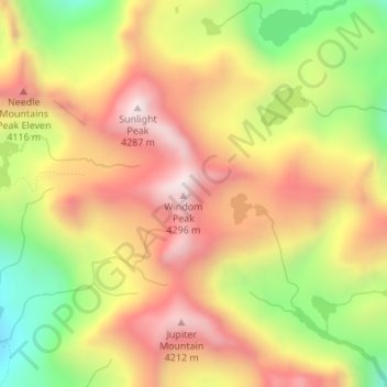
Name: Windom Peak topographic map, elevation, terrain.
Location: Windom Peak, La Plata County, Colorado, United States (37.62126 -107.59189 37.62136 -107.59179)
Average elevation: 12,762 ft
Minimum elevation: 11,247 ft
Maximum elevation: 13,927 ft
La Plata County trails, hiking, mountain biking, running and outdoor activities
Make a donation
Gear up for your next adventure:
As an Amazon Associate, this site earns from qualifying purchases at no extra cost to you.
Other topographic maps
Click on a map to view its topography, its elevation and its terrain.
Durango
United States > Colorado > La Plata County
Durango is set within a striking and diverse topography characterized by its elevation of 6,512 feet above sea level and its position in the Animas River Valley. The city lies at the foothills of the rugged La Plata Mountains to the west and is flanked by the San Juan Mountains to the north and east. This…
Average elevation: 7,093 ft
Make a donation
Gear up for your next adventure:
As an Amazon Associate, this site earns from qualifying purchases at no extra cost to you.
Durango
United States > Colorado > La Plata County
Durango is located at 37°16′N 107°52′W / 37.267°N 107.867°W / 37.267; -107.867 at an elevation of 6,512 ft (1,988 m). At the 2020 United States Census, the town had a total area of 10,946 acres (44.296 km2) including 1,533 acres (6.203 km2) of water.
Average elevation: 7,093 ft
Make a donation
Gear up for your next adventure:
As an Amazon Associate, this site earns from qualifying purchases at no extra cost to you.