
Make a donation
Gear up for your next adventure:
As an Amazon Associate, this site earns from qualifying purchases at no extra cost to you.
Betafo topographic map
Click on the map to display elevation.
Make a donation
Gear up for your next adventure:
As an Amazon Associate, this site earns from qualifying purchases at no extra cost to you.
About this map
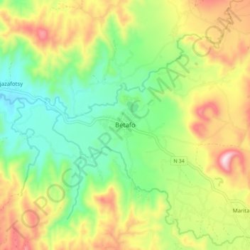
Name: Betafo topographic map, elevation, terrain.
Location: Betafo, Province d’Antananarivo, Madagascar (-19.87855 46.81623 -19.79855 46.89623)
Average elevation: 4,918 ft
Minimum elevation: 4,190 ft
Maximum elevation: 5,997 ft
Make a donation
Gear up for your next adventure:
As an Amazon Associate, this site earns from qualifying purchases at no extra cost to you.
Other topographic maps
Click on a map to view its topography, its elevation and its terrain.
Madagascar
Madagascar > Province d’Antananarivo
L’île de Madagascar s’est séparée du continent africain il y a environ 120 millions d'années, en raison de la dérive des continents. Elle peut être divisée en cinq régions géographiques : la côte est, le massif Tsaratanana, les hauts plateaux du centre, la côte ouest et le sud-ouest. Les…
Average elevation: 472 ft