
Thank you for supporting this site ❤️
Make a donation
Make a donation
Gear up for your next adventure:
As an Amazon Associate, this site earns from qualifying purchases at no extra cost to you.
Chéraga topographic map
Click on the map to display elevation.
Thank you for supporting this site ❤️
Make a donation
Make a donation
Gear up for your next adventure:
As an Amazon Associate, this site earns from qualifying purchases at no extra cost to you.
About this map
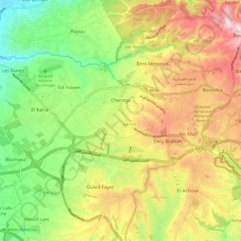
Name: Chéraga topographic map, elevation, terrain.
Location: Chéraga, Chéraga District, Algiers, Algeria (36.73455 2.87439 36.78433 2.98315)
Average elevation: 607 ft
Minimum elevation: 33 ft
Maximum elevation: 1,273 ft
Thank you for supporting this site ❤️
Make a donation
Make a donation
Gear up for your next adventure:
As an Amazon Associate, this site earns from qualifying purchases at no extra cost to you.
Other topographic maps
Click on a map to view its topography, its elevation and its terrain.
Dely Brahim
Algeria > Algiers > Cheraga District > Dély Brahim > Dely Brahim
Average elevation: 679 ft