
Make a donation
Gear up for your next adventure:
As an Amazon Associate, this site earns from qualifying purchases at no extra cost to you.
Affoltern am Albis topographic map
Click on the map to display elevation.
Make a donation
Gear up for your next adventure:
As an Amazon Associate, this site earns from qualifying purchases at no extra cost to you.
Affoltern am Albis
Affoltern liegt an den bewaldeten Höhenzügen zwischen Albiskette und Reuss, die während der letzten Eiszeit geformt wurden, und ist seit dem 12. Jahrhundert namentlich bezeugt. Die politische Gemeinde gliederte sich im 19. Jahrhundert in die Zivilgemeinden Ober- und Unteraffoltern, Zwillikon und Loo-Fehrenbach.
Make a donation
Gear up for your next adventure:
As an Amazon Associate, this site earns from qualifying purchases at no extra cost to you.
About this map
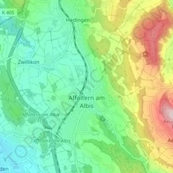
Name: Affoltern am Albis topographic map, elevation, terrain.
Location: Affoltern am Albis, Bezirk Affoltern, Zürich, Schweiz (47.26330 8.41467 47.30068 8.47746)
Average elevation: 1,801 ft
Minimum elevation: 1,404 ft
Maximum elevation: 2,657 ft
Make a donation
Gear up for your next adventure:
As an Amazon Associate, this site earns from qualifying purchases at no extra cost to you.
Other topographic maps
Click on a map to view its topography, its elevation and its terrain.