
Make a donation
Gear up for your next adventure:
As an Amazon Associate, this site earns from qualifying purchases at no extra cost to you.
Oos topographic map
Click on the map to display elevation.
Make a donation
Gear up for your next adventure:
As an Amazon Associate, this site earns from qualifying purchases at no extra cost to you.
Oos
Gut 400 Meter Höhenunterschied hat sie vom Quellgebiet in nördlicher Richtung zu passieren, bis die Oos bei Gaisbach mit dem Rubach zusammenfließt und dessen Talrichtung westwärts folgt.
Make a donation
Gear up for your next adventure:
As an Amazon Associate, this site earns from qualifying purchases at no extra cost to you.
About this map
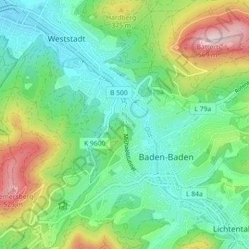
Name: Oos topographic map, elevation, terrain.
Average elevation: 745 ft
Minimum elevation: 354 ft
Maximum elevation: 2,329 ft
Make a donation
Gear up for your next adventure:
As an Amazon Associate, this site earns from qualifying purchases at no extra cost to you.
Other topographic maps
Click on a map to view its topography, its elevation and its terrain.
Korbmatten Baden-Baden
Deutschland > Baden-Württemberg > Landkreis Rastatt > Baden-Baden > Steinbach
Average elevation: 446 ft