Geolocate

Chatham topographic map

Click on the map to display elevation.

About this map

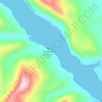
Name: Chatham topographic map, elevation, terrain.

Location: Chatham, Sitka, Alaska, United States (57.49365 -134.96258 57.53365 -134.92258)

Average elevation: 417 ft

Minimum elevation: -10 ft

Maximum elevation: 1,775 ft

Sitka trails, hiking, mountain biking, running and outdoor activities

Other topographic maps

Click on a map to view its topography, its elevation and its terrain.

Beaver Lake

United States > Alaska > Sitka > Sitka

Average elevation: 1,027 ft

Gear up for your next adventure:

🧭Map Reading Tools - Tools and kits for map navigation
😴Insulated Sleeping Pads - Compact and warm pads for high-elevation camping
💧Water Filtration Bottles - Safely drink from streams and lakes while exploring
🧼Biodegradable Camping Soap - Eco‑friendly soap for outdoor hygiene
❄️Traction Cleats - Prevent slips on icy trails during winter hikes

As an Amazon Associate, this site earns from qualifying purchases at no extra cost to you.