
Make a donation
Gear up for your next adventure:
As an Amazon Associate, this site earns from qualifying purchases at no extra cost to you.
Καλαμάκι topographic map
Click on the map to display elevation.
Make a donation
Gear up for your next adventure:
As an Amazon Associate, this site earns from qualifying purchases at no extra cost to you.
About this map
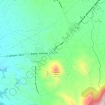
Name: Καλαμάκι topographic map, elevation, terrain.
Average elevation: 1,129 ft
Minimum elevation: 640 ft
Maximum elevation: 2,418 ft
Make a donation
Gear up for your next adventure:
As an Amazon Associate, this site earns from qualifying purchases at no extra cost to you.
Other topographic maps
Click on a map to view its topography, its elevation and its terrain.
Proti
Greece > Peloponnese, Western Greece and the Ionian > Messenia Regional Unit > Gargalianoi Municipal Unit
Average elevation: 52 ft
Palace of Nestor
Greece > Peloponnese, Western Greece and the Ionian > Messenia Regional Unit > Chora > Pisaski
Average elevation: 479 ft
Municipality of Pylos and Nestor
Greece > Peloponnese, Western Greece and the Ionian > Messenia Regional Unit
Average elevation: 331 ft
Sapientza
Greece > Peloponnese, Western Greece and the Ionian > Messenia Regional Unit > Methoni Municipal Unit
Average elevation: 49 ft
Make a donation
Gear up for your next adventure:
As an Amazon Associate, this site earns from qualifying purchases at no extra cost to you.
Schiza
Greece > Peloponnese, Western Greece and the Ionian > Messenia Regional Unit > Methoni Municipal Unit
Average elevation: 66 ft