
Make a donation
Gear up for your next adventure:
As an Amazon Associate, this site earns from qualifying purchases at no extra cost to you.
Santo Antão do Tojal topographic map
Click on the map to display elevation.
Make a donation
Gear up for your next adventure:
As an Amazon Associate, this site earns from qualifying purchases at no extra cost to you.
About this map
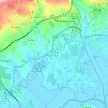
Name: Santo Antão do Tojal topographic map, elevation, terrain.
Location: Santo Antão do Tojal, Loures, Lisboa, 2660-161, Portugal (38.83406 -9.16323 38.87406 -9.12323)
Average elevation: 138 ft
Minimum elevation: 0 ft
Maximum elevation: 732 ft
Make a donation
Gear up for your next adventure:
As an Amazon Associate, this site earns from qualifying purchases at no extra cost to you.
Other topographic maps
Click on a map to view its topography, its elevation and its terrain.
Make a donation
Gear up for your next adventure:
As an Amazon Associate, this site earns from qualifying purchases at no extra cost to you.
Make a donation
Gear up for your next adventure:
As an Amazon Associate, this site earns from qualifying purchases at no extra cost to you.
Cabeço de Montachique
Portugal > Lisboa > Loures > Lousa > Cabeço de Montachique
Average elevation: 833 ft
Santa Iria de Azoia, São João da Talha e Bobadela
Average elevation: 121 ft
Make a donation
Gear up for your next adventure:
As an Amazon Associate, this site earns from qualifying purchases at no extra cost to you.