
Coromandel topographic map
Click on the map to display elevation.
About this map
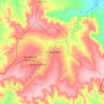
Name: Coromandel topographic map, elevation, terrain.
Average elevation: 3,035 ft
Minimum elevation: 2,516 ft
Maximum elevation: 3,327 ft
Other topographic maps
Click on a map to view its topography, its elevation and its terrain.
Vargem Grande do Rio Pardo
Vargem Grande do Rio Pardo has a total area of 494 km². The elevation is 800 meters. It became a municipality in 1997. It is part of the statistical microregion of Salinas and lies between BR-251 and the boundary with the state of Bahia. Neighboring municipalities are: Indaiabira, São João do Paraíso,…
Average elevation: 3,159 ft
Mato Verde
Mato Verde is a municipality located in the north of the state of Minas Gerais in Brazil. It was founded in 1953. The population was 12,412 as of 2020 and the area was 664 km2 (256 sq mi). The elevation of the city is 541 metres. The postal code (CEP) is 39527-000.
Average elevation: 2,405 ft
Pimenta
The city center of Pimenta is located at an elevation of 776 meters on a northern arm of the great reservoir of Furnas. Neighboring municipalities are: Pains (N), Formiga (E), Guapé, and Piumhi (W).
Average elevation: 2,782 ft
Delfinópolis
The city center of Delfinópolis is located at an elevation of 745 meters on the northern bank of the Represa dos Peixotos, which dams up the Rio Grande. The elevation varies from a maximum of 1,400 meters to a minimum of 671 meters. Neighboring municipalities are: São Roque de Minas (N), São João Batista…
Average elevation: 3,077 ft
Ouro Verde de Minas
Ouro Verde de Minas is located at an elevation of 549 meters, 49 km. southeast of Teófilo Otoni. The distance to the state capital, Belo Horizonte, is 494 km. Neighboring municipalities are: Teófilo Otoni, Ataléia, and Frei Gaspar.
Average elevation: 1,791 ft
Belo Horizonte
In 1893, due to the climatic and topographic conditions, Curral Del Rey was selected by Minas Gerais governor Afonso Pena among other cities as the location for the new economic and cultural center of the state, under the new name of Cidade de Minas, or City of Minas.
Average elevation: 2,936 ft
Morada Nova de Minas
Morada Nova de Minas belongs to the statistical micro-region of Três Marias. It is located at an elevation of 594 meters on the banks of the Três Marias Dam, which dams up the São Francisco River. Neighboring municipalities are.
Average elevation: 2,205 ft
Belo Horizonte
In 1889 Brazil became a republic, and it was agreed that a new state capital, in tune with a modern and prosperous Minas Gerais, had to be established. In 1893 due to the climatic and topographic conditions, Curral Del Rey was selected by Minas Gerais governor Afonso Pena among other cities as the location for…
Average elevation: 2,936 ft
Itajubá
Itajubá is a municipality in southeastern Minas Gerais state of the Federative Republic of Brazil. It lies in a valley by the Sapucaí river and has terrain elevations ranging from 827 to 1500 metres, occupying an area of 290.45 km2 (112.14 mi2), with a population of 97,334 people (2020 est). Neighboring the…
Average elevation: 3,445 ft
Leandro Ferreira
The city center of Leandro Ferreira is located at an elevation of 700 m (2,300 ft) on state highway MG-235, in the Serra da Saudade mountains. Neighboring municipalities are: Martinho Campos (N), Pitangui and Conceição do Pará (E), Nova Serrana (S), and Bom Despacho (W).
Average elevation: 2,349 ft
Santa Fé de Minas
Santa Fé de Minas is located about 130 km. northwest of the nearest major population center, Pirapora at an elevation of 493 meters. Neighboring municipalities are: São Romão, Buritizeiro, Brasilândia de Minas, and Bonfinópolis de Minas. It is part of the statistical microregion of Pirapora.
Average elevation: 1,886 ft
Belo Horizonte
In 1889 Brazil became a republic, and it was agreed that a new state capital, in tune with a modern and prosperous Minas Gerais, had to be established. In 1893 due to the climatic and topographic conditions, Curral Del Rey was selected by Minas Gerais governor Afonso Pena among other cities as the location for…
Average elevation: 2,936 ft
Lavras
Lavras is a municipality in southern Minas Gerais state, Brazil. Located at an altitude of 919 m, it has a population of 104,761 inhabitants (2022 Census). The area of the municipality is 564.495 km2. The average annual temperature is 19.6 °C and the average annual rainfall is 1,511 millimetres.
Average elevation: 2,959 ft
Espinosa
Espinosa is a municipality in the north of the state of Minas Gerais, Brazil. Its population was 32,151 (2015) and its area is 1,869 km2. The elevation is 572 meters.
Average elevation: 2,431 ft
Presidente Bernardes
Presidente Bernardes is a municipality in the state of Minas Gerais in Brazil. The population is 5,341 (2020 est.) in an area of 237 km2. The elevation is 591 m. Presidente Bernardes is named after President Artur Bernardes.
Average elevation: 2,323 ft
Araçuaí
Araçuaí (Portuguese pronunciation: [aɾɐswa'i]) is a Brazilian municipality located in the northeast of the state of Minas Gerais in the Jequitinhonha River valley. The Araçuaí River, a tributary of the Jequitinhonha, flows through it. Its population as of 2020 was estimated to be 36,712 people living in…
Average elevation: 1,759 ft
Boa Esperança
Boa Esperança is located in the southern-tropical part of Brazil, at 21 degrees, 5 minutes, 24 second south, and 45 degrees, 33 minutes, 57 seconds west, at an altitude of 775 metres (2,543 ft), in the internal part of the State of Minas Gerais. It covers an area of 860.669 square kilometres (332.306 sq mi).
Average elevation: 2,851 ft
Parque Nacional do Itatiaia
Brazil > Minas Gerais > Itamonte
Itatiaia National Park was created on 14 June 1937 by President Getúlio Vargas, the first of 76 such parks. The park is in the Mantiqueira Mountains. It covers parts of the municipalities of Itatiaia and Resende in Rio de Janeiro state, and Bocaina de Minas and Itamonte in Minas Gerais state. It is…
Average elevation: 5,253 ft
Uberlândia
Uberlândia's average elevation is 887 m. The highest point in the municipality is located at the headwaters of Cachoeirinha Stream, measuring 930 m. The lowest elevation is at the mouth of the Uberabinha River, at 622 m. The municipal seat is situated at an elevation of 863.18 m. The municipality is located…
Average elevation: 2,697 ft
Ubá
The city sits in a valley and has only 5% of its area flat, the rest being rugged. The altitude ranges from 295 meters to 875 meters.
Average elevation: 1,519 ft
Taiobeiras
Taiobeiras is a municipality in the north of the state of Minas Gerais in Brazil. As of 2020 the population was 34,397 in an area of 1,194 km2. The elevation of the municipal seat is 821 meters. It became a municipality in 1953. The postal code (CEP) is 39550-000 and it belongs to the statistical microregion…
Average elevation: 2,602 ft
Patis
Patis is located at an elevation of 771 meters, about 90 km. north of the regional center of Montes Claros. It is 17 km. east of highway BR-135, which connects Montes Claros to Januária. It belongs to the statistical microregion of Montes Claros. Neighboring municipalities are Brasília de Minas, Japonvar,…
Average elevation: 2,500 ft
Cabo Verde
The city center of Cabo Verde is located at an elevation of 927 meters a short distance from the state boundary of São Paulo. Neighboring municipalities are: Monte Belo (N), Areado (NE), Divisa Nova (E), Botelhos (S), Caconde (W) and Muzambinho (NW).
Average elevation: 3,074 ft
João Monlevade
The city center has an average elevation of 580.57 meters. The highest point in the municipality is in the Serra do Seara, reaching an elevation of 1,340 meters. The terrain is predominantly mountainous, with 68% of the municipal territory consisting of rolling hills and mountains, 20% undulating areas, and…
Average elevation: 2,667 ft
Serra da Mantiqueira
Brazil > Minas Gerais > Passa Quatro
The Serra da Mantiqueira is a part of the Atlantic Forest ecosystem. Despite the clearing of the land for livestock raising, the difficult access to many areas has made possible for sanctuaries of well-preserved forest to still exist, with trees such as the jacarandá, Spanish cedar, canjerana, guatambu, ipê,…
Average elevation: 7,451 ft
Brumadinho
Brumadinho (Brazilian Portuguese: [bɾumaˈdʒiɲu]) is a Brazilian municipality in the state of Minas Gerais. The city belongs to the Belo Horizonte metropolitan mesoregion and to the microregion of Belo Horizonte. Brumadinho is at an altitude of 880 m. In 2020 the population was 40,666. The municipality is…
Average elevation: 2,917 ft
Belo Horizonte
Brazil > Minas Gerais > Região Metropolitana de Belo Horizonte
In 1893, due to the climatic and topographic conditions, Curral Del Rey was selected by Minas Gerais governor Afonso Pena among other cities as the location for the new economic and cultural center of the state, under the new name of Cidade de Minas, or City of Minas.
Average elevation: 2,936 ft
Belo Horizonte
In 1893 due to the climatic and topographic conditions, Curral Del Rey was selected by Minas Gerais governor Afonso Pena among other cities as the location for the new economic and cultural center of the state, under the new name of Cidade de Minas, or City of Minas.
Average elevation: 2,936 ft
Cabo Verde
The city center of Cabo Verde is located at an elevation of 927 meters a short distance from the state boundary of São Paulo. Neighboring municipalities are: Monte Belo (N), Areado (NE), Divisa Nova (E), Botelhos (S), Caconde (W) and Muzambinho (NW).
Average elevation: 3,074 ft
Três Pontas
The municipality don't have a rugged relief (the average level is 900m), there are only three areas in which the altitude reaches 1100m above sea level. One of them is the Serra de Três Pontas (Three Tips Mountain), a place known in the region for its distinctive shape and natural environment. The streams…
Average elevation: 2,917 ft
Araxá
The elevation of the city center is 973 metres (3,192 ft). The highest point in the municipality is Serrra da Bocaina at 1,359 metres (4,459 ft), and the lowest point is the Capivara river at 910 metres (2,990 ft). In 2004 the annual average temperature was 20.98 °C (69.76 °F), and the annual rainfall was…
Average elevation: 3,379 ft
Ipatinga
In 1956, a Japanese commission visited the then-district of Ipatinga, selecting it as the site for the Usiminas steel plant. Factors influencing this decision included suitable topography, proximity to raw material sources and consumer markets, availability of water resources, abundant electricity, local…
Average elevation: 1,079 ft
Carmo da Cachoeira
Carmo da Cachoeira is a Brazilian municipality in the south of the state of Minas Gerais. In 2020 its estimated population was 12,182 in a total area of 506 km2. The elevation is 959 meters.
Average elevation: 3,159 ft
Juiz de Fora
Although lying within tropical latitudes the climate is relatively mild. The altitude of 700 to 900 m (2,300 to 3,000 ft) makes the weather usually cooler and rainier than the lower surrounding areas. Under the Köppen climate classification Juiz de Fora's climate is classified as a humid subtropical climate…
Average elevation: 2,215 ft
Brumadinho
Brazil > Minas Gerais > Região Metropolitana de Belo Horizonte
Brumadinho (Brazilian Portuguese: [bɾumaˈdʒiɲu]) is a Brazilian municipality in the state of Minas Gerais. The city belongs to the Belo Horizonte metropolitan mesoregion and to the microregion of Belo Horizonte. Brumadinho is at an altitude of 880 m. In 2020 the population was 40,666. The municipality is…
Average elevation: 2,917 ft
Betim
Brazil > Minas Gerais > Região Metropolitana de Belo Horizonte
Betim is located on the southwest of Belo Horizonte IGR, with Rio Paraopeba flowing through its south. Its average elevation is 830 meters above the sea level.
Average elevation: 2,720 ft
São Tomé das Letras
It's elevation, at points 1,440 meters above sea level, allows for a panoramic view of enclosed region around it. This makes the town a preferred destination of tourists interested in nature. A soap opera of the not defuncr Manchete TV also attracted tourists to the area.
Average elevation: 3,294 ft
Governador Valadares
In general, the municipal territory is divided into two geomorphological units: 60% of the Valadares territory is undulating, 25% is rugged and 15% is flat. The areas to the south, where the urban perimeter is located, are located in the interplanal depression of the Rio Doce Valley, whose relief is the result…
Average elevation: 1,030 ft
Jardim Teresópolis
Brazil > Minas Gerais > Região Metropolitana de Belo Horizonte > Betim
Average elevation: 2,940 ft
Bambuí
The city center of Bambuí is located at an elevation of 706 meters on a plateau and straddles the 20th parallel. Neighboring municipalities are: Tapiraí and Córrego Danta (N), Luz (NE), Iguatama (E), Doresópolis (SE), Piumhi (S), São Roque de Minas and Medeiros (W).
Average elevation: 2,425 ft
Campos Altos
Campos Altos is located at an elevation of 1,050 m (3,440 ft), 85 km (53 mi) east of Araxá on highway BR-216. The distance to the state capital, Belo Horizonte, is 264 km (164 mi). Neighboring municipalities are: Rio Paranaíba (N), São Gotardo (NE), Santa Rosa da Serra (E), Córrego Danta, (SE) Tapiraí…
Average elevation: 3,399 ft
Alfenas
Alfenas is a municipality in the southern part of the Brazilian state of Minas Gerais. In 2020 its population was 80,494 and the area of the municipality is 849 km2. The elevation is 888m. It is served by highways MG 179, BR 491 and BR 369. The distance to the state capital of Belo Horizonte is 335 km and the…
Average elevation: 2,713 ft
Teófilo Otoni
It lies at an elevation of 319 meters on the Todos os Santos River, a tributary of the Mucuri. It is part of the Valley of the Mucuri, a region which includes 27 municipalities. Situated on the Rio-Bahia Interstate Highway BR 116, it is 130 km. north of the regional center, Governador Valadares, on the Doce…
Average elevation: 1,775 ft
Betim
Betim is located on the southwest of Belo Horizonte IGR, with Rio Paraopeba flowing through its south. Its average elevation is 830 meters above the sea level.
Average elevation: 2,720 ft
Lagoa dos Ingleses
Brazil > Minas Gerais > Região Metropolitana de Belo Horizonte > Nova Lima
Average elevation: 4,380 ft
Tiradentes
Tiradentes is a municipality in the Brazilian state of Minas Gerais. It is located at 21°06′37″S 44°12′41″W / 21.11028°S 44.21139°W / -21.11028; -44.21139, has an area of 83.5 km2 (32.2 sq mi), and a maximum elevation above sea level of 927 m. Tiradentes had an estimated population of…
Average elevation: 3,182 ft
Nanuque
Nanuque is located in the valley of the Mucuri River at an elevation of 131 meters. It lies in a corner of Minas Gerais with the boundary lines of Bahia to the north and east, and that of Espírito Santo to the south. The Serra dos Aimorés lies to the north.
Average elevation: 689 ft
Campina Verde
Campina Verde is located at an elevation of 530 meters north of the Rio Grande, a tributary of the Paraná River. It is 70 km. west of federal highway BR-153 (Transbrasiliana). It belongs to the statistical microregion of Frutal. Neighboring municipalities are.
Average elevation: 1,811 ft
Itapagipe
Itapagipe is located at an elevation of 516 meters in the south-center of the area known as the Triângulo Mineiro 37 km. west of the Transbrasiliana highway—Br-153. The Rio Grande, a tributary of the Paraná River, forms its southern boundary. It belongs to the statistical micro-region of Frutal.…
Average elevation: 1,683 ft
Bocaiuva
The municipal seat is located at an elevation of 710 meters on the north flank of the Serra do Espinhaço mountain range. Highway connections are made by a feeder road (4 km) to BR-135, which connects to Montes Claros, to the north. Neighboring municipalities are: Montes Claros, Engenheiro Navarro,…
Average elevation: 2,779 ft
Jaboticatubas
Brazil > Minas Gerais > Região Metropolitana de Belo Horizonte
Average elevation: 2,910 ft