
Make a donation
Gear up for your next adventure:
As an Amazon Associate, this site earns from qualifying purchases at no extra cost to you.
Vilsalpsee topographic map
Click on the map to display elevation.
Make a donation
Gear up for your next adventure:
As an Amazon Associate, this site earns from qualifying purchases at no extra cost to you.
Vilsalpsee
Das Gebiet um den Vilsalpsee steht seit 1957 unter Naturschutz und gehört heute zum Naturschutzgebiet Vilsalpsee, das auch Natura-2000-Gebiet ist. Es erstreckt sich über die Gemeindegebiete von Tannheim und Weißenbach (beide Bezirk Reutte) und inkludiert die höhergelegenen Lache, Traualpsee und den Alplsee.
Make a donation
Gear up for your next adventure:
As an Amazon Associate, this site earns from qualifying purchases at no extra cost to you.
About this map
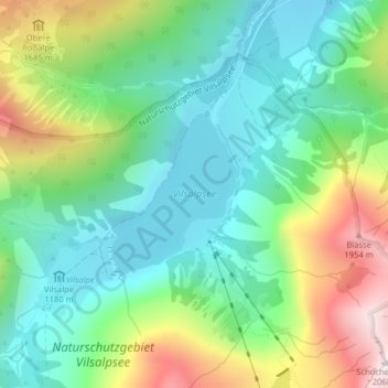
Name: Vilsalpsee topographic map, elevation, terrain.
Location: Vilsalpsee, Tannheim, Bezirk Reutte, Tirol, 6675, Österreich (47.45837 10.49569 47.46959 10.50871)
Average elevation: 4,692 ft
Minimum elevation: 3,747 ft
Maximum elevation: 6,670 ft
Make a donation
Gear up for your next adventure:
As an Amazon Associate, this site earns from qualifying purchases at no extra cost to you.