
Make a donation
Gear up for your next adventure:
As an Amazon Associate, this site earns from qualifying purchases at no extra cost to you.
Steinheim topographic map
Click on the map to display elevation.
Make a donation
Gear up for your next adventure:
As an Amazon Associate, this site earns from qualifying purchases at no extra cost to you.
Steinheim
Im Norden befindet sich der 493 Meter hohe Buchberg, ein Schwemmkegel vor dem glazialen Abflusstal der Donau, der den Ort um ca. 25 Meter überragt. Am Fuß des Hügel in südlicher Lage, befindet sich heute noch Überreste eines Bierkellers. Dieser unterstreicht die frühere Bedeutung der Anhöhe als Ausflugsziel mit Wochenendhäusern.
Make a donation
Gear up for your next adventure:
As an Amazon Associate, this site earns from qualifying purchases at no extra cost to you.
About this map
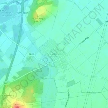
Name: Steinheim topographic map, elevation, terrain.
Location: Steinheim, Neu-Ulm, Landkreis Neu-Ulm, Bayern, Deutschland (48.39531 10.09988 48.40341 10.11080)
Average elevation: 1,552 ft
Minimum elevation: 1,512 ft
Maximum elevation: 1,683 ft
Make a donation
Gear up for your next adventure:
As an Amazon Associate, this site earns from qualifying purchases at no extra cost to you.
Other topographic maps
Click on a map to view its topography, its elevation and its terrain.
Schloss
Deutschland > Bayern > Landkreis Neu-Ulm > Neu-Ulm > Holzschwang
Holzschwang liegt am östlichen Rande des Höhenzuges zwischen Iller und Roth auf einer Höhe zwischen 490 und 520 m ü. NN und bildet den süd-östlichst gelegenen Ortsteil Neu-Ulms. Die Entfernung zum Stadtzentrum beträgt rund 10 km über die unmittelbar am westlichen Ortsrand entlang verlaufende…
Average elevation: 1,650 ft