
Mestia topographic map
Click on the map to display elevation.
Mestia
Mestia (Georgian: მესტია IPA: [mestʼia]) is a highland townlet (daba) in northwest Georgia, at an elevation of 1,500 metres (4,921 feet) in the Caucasus Mountains.
About this map
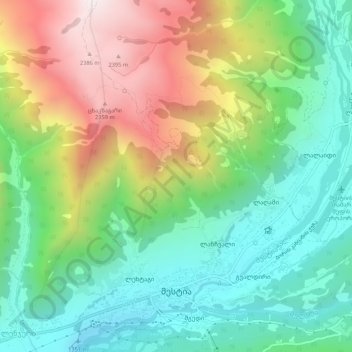
Name: Mestia topographic map, elevation, terrain.
Location: Mestia, Mestia Municipality, Samegrelo-Upper Svaneti, Georgia (43.03789 42.70927 43.07569 42.76129)
Average elevation: 5,778 ft
Minimum elevation: 4,390 ft
Maximum elevation: 8,051 ft
Other topographic maps
Click on a map to view its topography, its elevation and its terrain.
Ushguli
Georgia > Samegrelo-Upper Svaneti > Mestia Municipality
Ushguli is located at an altitude of 2,100 metres (6,900 ft) near the foot of Shkhara, one of the highest summits of the Greater Caucasus mountains. About 70 families (about 200 people) live in the area, enough to support a small school. The area is snow-covered for 6 months of the year, and often the road to…
Average elevation: 7,904 ft
Very steep, dangerous route
Georgia > Samegrelo-Upper Svaneti > Mestia Municipality
Average elevation: 6,152 ft
Paledi
Georgia > Samegrelo-Upper Svaneti > Mestia Municipality > Gheshderi
Average elevation: 5,364 ft