
Thank you for supporting this site ❤️
Make a donation
Make a donation
Gear up for your next adventure:
As an Amazon Associate, this site earns from qualifying purchases at no extra cost to you.
Weissmies topographic map
Click on the map to display elevation.
Thank you for supporting this site ❤️
Make a donation
Make a donation
Gear up for your next adventure:
As an Amazon Associate, this site earns from qualifying purchases at no extra cost to you.
About this map
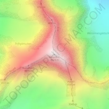
Name: Weissmies topographic map, elevation, terrain.
Location: Weissmies, Saas-Almagell, Visp, Wallis, 3905, Schweiz (46.12758 8.01201 46.12768 8.01211)
Average elevation: 10,860 ft
Minimum elevation: 8,668 ft
Maximum elevation: 13,153 ft
Thank you for supporting this site ❤️
Make a donation
Make a donation
Gear up for your next adventure:
As an Amazon Associate, this site earns from qualifying purchases at no extra cost to you.
Other topographic maps
Click on a map to view its topography, its elevation and its terrain.